I was walking across a boulder field beneath the cliffs of Casa Grande when the wonder of it stopped me mid-stride. In a process largely unconscious, several years worth of steps had accumulated into an ability to look at the rocks lying ahead of me, size up their mass and center of gravity, combine that with their position, determine which rocks would be stable and finally decide where upon that rock would be the most secure place to place my passing weight and direct my foot to that place, all within the time interval between walking steps.
How had I learned that? I had read no book nor taken a class along the way. The knowledge just accumulated over time. Initial forays on rock slides back in college had been very tentative because rocks do tip or slide. I spent more time tentatively testing rocks before committing full weight. But with each step and with each movement of rock, I was learning the patterns of predictable stability until now I just walked across a rock slide with the casualness of walking along a sidewalk. This was a learning very different from school learning where conclusions were distilled down to words delivered by others with little context other than it might be needed for an upcoming paper test, nothing more. Rather than filing the words of others into some tiny part of my brain, the kinesthetic contact with rock masses rose up through my body over and over again until they shape thoughts and actions with absolute veracity. Convictions held by my whole body, not because of what someone else has said, but because of daily visceral truth-testing with the world. These learnings of humble origin but deep roots I came to call “trail lessons”. Because they gradually arise through experience into consciousness, it’s often hard to pin them to a specific time and place, but hiking the wide-open spaces of Big Bend incubated many. Though they will lack the heft of repeated experience for you, I pass some on as seed thoughts to plant in the soil of your experience.
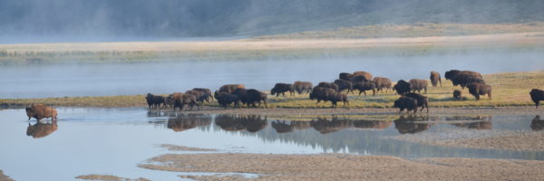
Once I had hiked all of Big Bend’s car-accessible trails, I started to venture out beyond them. The easiest way to do this was by hiking up dry streambeds. They coursed through all parts of the desert. “Hiking up” is meant literally; walking upstream against the direction of their ephemeral water’s flow, up towards their headwaters. That direction always eventually led to a high spot with a view and without danger of getting lost. Even though streambeds fork over and over again as I walk up them, requiring me to make choice after choice which way to turn, I can’t get lost. I can follow the streambed to any one of its innumerable tiny beginnings and, when ready, turn around and follow it back down without a thought. The streambed will lead me right back to my car because a drainage does not fork flowing downstream. It converges. (There are local exceptions, such as the Yukon Flats, where the drainage comes to a level area and the current has to slow down and deposit some of its bedload.) Drainages converge as they flow downstream, a pattern that begins with individual raindrops (such as we see on raindy-day windows creeping down and merging together) and ends with mighty rivers flowing back down to the sea. This pattern of convergence forms one of the foundational phrases in the language of that golden book.

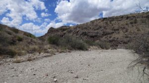
I walked up a lot of dry streambeds in Big Bend and the language of streambeds rose up through my soles. The first place I started noticing these patterns was where the firm streambed turned into loose sand and my feet would slide back with every step. Walking became a tedious trudge across a perfectly flat sand flat without any slope to lend a gravity assist. Eventually, the streambed firmed up again and I continued on, but I would promise to pay more attention and avoid it next time. These sand traps were rare but when they were occurred, they were unavoidable unless I wanted to climb out of the streambed and walk through the bordering vegetation.
On the other hand, my favorite places were where the sands and gravels disappeared and the streambed was only exposed bedrock. These places had been sanded into wonderfully sinuous shapes by grit-laden flash floods. In such places, the bedrock curved up, embracing the bottom of the stream. These places were distinctively unique and beautiful. Walking shifted towards dancing within these spaces. These stretches of bedrock-defined streambed are steeper and narrower than average. I can sense how these places act like a nozzle on a garden hose, increasing the pressure of the water jetting through, flushing out any loose material.
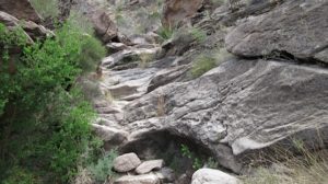
I can see and feel how this bedrock is distinct from the other areas the stream has flowed across. This bedrock is harder, more resistant to erosion. Not only do the bordering slopes rise more steeply on either side, the angle of the stream bed also steepens. This is an example of what geologists call differential erosion. Some rocks erode slower than others. Because they aren’t worn down as fast as the surrounding rock, over time, they rise higher and steeper than the surrounding rock. They surround themselves with cliffs. They are the sites of waterfalls and desert pouroffs. Differential erosion is an important factor shaping the land and I can feel it through my feet as I follow the streambeds.
Those other places of loose, fine sand in which my feet tediously slip as I push my way ahead? Those places are always broad and flat with no slope to help me through them. The consistent correlation between flat and sandy help me understand what is happening. The floodwaters slowed down as they flowed across these flat stretches. As they lost energy, they had to drop some of their sandy loads (like in the Yukon Flats).
Most streambeds are somewhere in between these two extremes. The sand gives way to gravel; a place where the water had enough energy to keep carrying the sand but not enough energy to keep moving the larger, heavier gravels. There they settled.
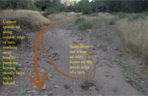
When a streambed curves, it changes; the inside of the bend becomes sandy while the outside bend becomes rocky. I remember how the power of the Grand Ronde piled up against the outside bend of each turn and this pattern makes sense. Only large rocks can hold their place in the strong flow scraping along the outside curve. The current is much slower on the inside of the bend; gravels and sands can come to rest and hold their place within that slower flow.
As I grew more conversant in the language of streambeds, I realized that the language of the streambed is the fossilized language of flowing water. The slower the water flowed, the broader and sandier the streambed. The faster the water flowed, the narrower and rockier the streambed. What my feet feel underfoot amplifies what my eyes see: a correlation between the streambed’s width and the size of the rocks on its surface. The width is always changing just as the feel of the streambed is always changing.
Later, I would come to understand this as a consequence of the stream discharge equation, but right now it was flowing in, not as a mathematical pattern but as the kinesthetic feel and sound of different streambeds underfoot.
As I follow the streambeds up towards their headwaters, they grow narrower and steeper. These two changes are connected. The streambeds narrow because I am moving upstream, passing the converging tributaries that contribute their runoff into the streambed. The higher I climb, the less area remains above to gather rain into the streambed, so the streambed becomes narrower because there is less water to carry. As water flows downstream and converges with other tributaries down there, the greater flow will grow in width, widening the streambed.
Because there is less runoff the higher I go in the drainage, there is less erosive energy to wear the streambeds down into the bedrock. The high slopes and their streambeds stay steep. If the channel gets worn down towards a gentler grade, the erosive power of runoff slows down. Therefore, the upper streambeds remain steeper than the lower streambeds.
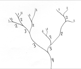
Geologists who want to translate the language of streambeds into mathematical graphs have created a numbering method called stream order. Each section of a stream is given a number based on its relationship with the sections of other streams it converges with. The smallest streams at the headwaters are first order streams (1). Whenever two first order streams converge, they combine into a second order stream (2). When two second order streams converge, they combine into a third order stream (3). If a first or second order stream converges with a third order stream, they don’t change the stream order. The only time the stream order increases is when streams of the same order converge. So when a third order stream converges with another third order stream, then they combine to create a fourth order stream (4). Link to example: < http://rpgmaps.profantasy.com/wp-content/images/RulesORivers_html_b246a59.png >
Geologists can then organize a variety of hydrological data by stream order number and see patterns that arise due to the gradual convergence of water flowing downhill. There are a lot. Here is a link to an article that contains several stream order graphs.
https://www.s-cool.co.uk/a-level/geography/river-profiles/revise-it/drainage-basins
The steepening streambed forks more often as I follow it up towards its headwaters, presenting me more often with a choice of which path to follow. I don’t have to remember which one I take because they’ll all come together on the way down. Above each fork, the streambed narrows more. I come into sight of the ridges that define the upper edges of this drainage system. The forks continue happening more often but now they are only shallow, easily overlooked, ephemeral rivulets on the slopes I am ascending. There comes a time when I abandon the channels and scramble up the slopes the rest of the way. I sit on the ridgetop, resting. From there, I can look back over the drainage I ascended or look down upon the watershed on the other side of the ridge.
Because the stretches between convergences grow shorter, drainage patterns are fractal. The hundred foot-wide pattern near the headwater is remarkably similar to the mile wide pattern further downstream is remarkably similar to the thousand mile wide pattern of a mighty river gathering smaller rivers unto it.
Looking out from the ridgeline at the head of “my” drainage, I can see it bounded on either side by ridges that rise up to join the ridgeline, forming a basin. Beyond those side ridges lie the basins containing all the major stream forks that I did not take on my ascent. If I walk along the main ridgeline, I will traverse from the head of “my” basin to the head of others. Up here, I have the freedom to cross as many of these basins as I want and descend by whatever streambed calls to me, as long as it is part of my watershed. Theoretically it’s possible that descending another streambed might lead me to a pouroff I can’t descend. But I can always retrace my steps back up a way, go over one of the sub-ridges and drop into another streambed and try it out. It’s all part of the adventure of roaming streambeds. Eventually, the streambeds will lead me back to my starting point and my car.
I rarely started a hike going downstream, partly because of the patterns already mentioned. Heading downstream leads to wider, sandier streambeds along more level ground so there are fewer views out across the land. The walking is easier; gravity assists me striding along with little effort, allowing my mind to drift out over the land. That’s the trap. If I turn back halfway through my time or my energy or my water, I’ve gone too far. Returning will take longer because going was downhill and returning is uphill. Plus I started down in the cooler morning and now I have to return during the warmer afternoon. Even more insidious, when I do start back, the streambed will keep forking, presenting me with a choice. Right or left? Which one do I take? Many of these forks, I didn’t even notice as I strode downstream past them. Now, if I choose the wrong fork, that fork could lead me miles away from my car.
When hiking downstream, I need to be aware every time my streambed converges with another. I need to stop downstream of the fork, turn around. and look back up at the fork. That way I will see it the same way that I will on my return, so I can remember which side of the fork I came walking down.