Cairns #88
End of the Long Nights, 2017
Lessons from the Fields
Winter is my season for rain walks and we’ve had lots of rain this year. I feel like my rain walks are leading me to a whole new level of understanding that I strive to articulate. Without the fields around me, let me try describing (with lots of images) two explorations that are enchanting me.
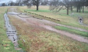
Much of my initial work in this new area has been along an old abandoned ranch road that cuts across a mile-wide slope, cuts across all the subtle vegetated drainages seeping down the slope and drain them onto this road. Now, instead of continuing to seep down the slope, they follow the road ruts, flowing on the surface, converging with all the other runoff seeping onto the road into a stream that follows the ruts quickly along to the low spots which are where the road crosses one of the larger streams in the area that drain quickly down to the Sacramento River a mile away.
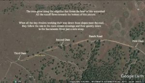 Aerial view of area I’ll be describing with location of my porous dams
In “Moving a Boulder” (Cairns # 84), I described the first (indicated above by Moved Rock) of many moves where I’ve opened the downslope side of the road so that the runoff captured by the road can flow back onto the slopes before it converges with those streams. I am amazed at how much of the runoff that I lead out of the ruts is being absorbed into the ground as it seeps its slow way downslope, free from the momentum of any stream channel.
This is the setting. Now let me describe the play that has taken me towards a new level. We are looking down on what I labeled above as First Dam. A drainage flows through a culvert under the abandoned road. The narrow culvert has created a gully at either end of it. To the right of the culvert, most of the road runoff drains into a grassy gutter that borders the upslope side of the road. The grassy gutter leads all this water to the gully just a few feet upstream of the culvert.
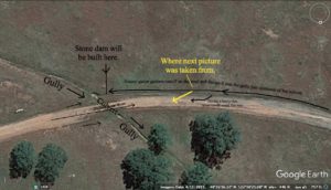 During a heavy rain, the grassy gutter swelled and a bit of the surge oozed onto the tracks of the road. (This is a low spot so the road is not rutted here.) The ooze led me to scratch a shallow path across the road to see if I could lead a bit of the water across the road rather than have it all go under the road through the culvert.
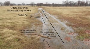
Then I realized there was another way to send more of this runoff across the road. What if I piled up some large rocks at the far end of the grassy gutter just before it dropped down into the gully of the culvert? It wouldn’t be enough to stop the flow but it didn’t have to be. It just needed to reduce the rate of flow in that direction so that it would back up, hopefully onto and over the road. It worked. Over the intervening weeks, I’ve added more rocks to the “dam” so that now, even during a mild rain, the situation looks like this.
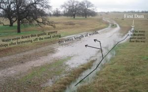 Now, instead of flowing down the “gutter”, the majority of the runoff crosses the road and oozes broadly down the grassy slope towards the stream on the left without any runoff moving over the surface. This play has nourished two strategies.
The first I call “porous stone dams”.
I’ve never thought of dams as a viable play. I found with small check dams, as the water backs up behind the dam, the hydraulic pressure exerted against the base of the dam increases until it finally blows out the dam. This usually happens when it overtops the dam and falls into a turbulent plunge pool that erodes and undermines the dam. And rock dams are clunky. They don’t fit together. You need lots of big rocs but they don’t stack stablely. Round rocks are easily moved aside by the force of the water. But what emerged in this situation led my mind in a new direction.
In this situation, as the water level rises, more and more of the flow is flowing across the road and down through the gentle slope, far away from the dam. This dramatically reduces the force the dam has to withstand. The second outlet gives strength to the dam.
 First Dam
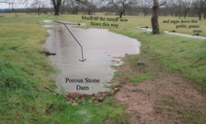
Here is the current situation from the other direction. You can see in the foreground the structure of the dam. I thought I needed large rocks but I don’t. It is layers of mostly small and medium rocks. Each time I walk by, I add a few more. I’m not trying to block all the water. The dam is porous; water still flows through it. I observe the flow and place a stone so that it clogs one of the places where water is pushing through between the current stones. Small rocks can fit in between the cracks. It might not seem like much but I know that through probabilistic shifts, each placement means the water won’t be able to flow through the dam quite as fast which means it must rise a little bit which means a bit more water will be flowing along on the new path across the road instead.
I call this a stone dam because, in my mind, a rock becomes a stone when you consciously come to know it in its unique identity. The process begins with picking up rocks that are lying on the ground, not rising up out of the ground. These rocks lying on the ground can not absorb either rainfall or sunlight. By removing them, I am opening more of the surface to these possibilities. I feel the balance of the rock’s weight as I carry it. I examine its angles and shape as I study where best to place it within the dam. In this process, it becomes a unique stone, not a generic rock. Placing each stone into a place that it fits gives the dam both a structural integrity and a beauty as the water flows thinly yet smoothly over the length of the dam.
The structural integrity comes about through a water-guided dance between height and length of the dam. If a stone raises the height of the dam, that causes the water level to rise which increases the pressure against the dam which pushes the water through the chinks with a bit more force, revealing new places for my next stone. If I stay focused on placing each stone on where the flows are strongest, the water will guide me to lengthen the dam in greater proportion than raising it. As the dam lengthens, any turbulent flow in its original configuration gradually smooths out into a non-erosive laminar flow as it flows through the length of the dam. And then the water reveals a place where a stone can be placed on the crest of the dam, raising the dam’s actual height a bit more.
The other place this play has led me to this winter in much harder to describe. This is my first attempt to capture some of it in words so it might get murky. I’ll start with this picture of two of my basic “plays”, a pattern I’ve made a thousand times.
For decades, I’ve enjoyed how ripples on the surface of the water flowing through my divergence channels guide my trowel to the precise point where lowering the bed of the channel will increase the rate of water flowing into the divergence.
 The ripple happens right where the water accelerates. It accelerates because beneath the ripple is the high point in the channel bottom. The flow backs up behind the high point until it overflows. Once it overflows, it accelerates down past the high point. My trowel removes this high point; now the water can flow along without any backing up. There is now a smoother grade leading runoff away from the original flow.
In these generic instances, the “offer a new channel” has always been close to the “opposing the old”. But with my porous stone dam, the new channel was fifty feet upstream. This dramatic split led my thoughts onto a new path which included being able to recognize other examples for such a play. Here is a second example.
 Second Dam
The stone dam is only a few inches high but it reroutes runoff many tens of feet away. The reason it is so effective is that I built it where the surface of the water rippled as it flowed out of that puddle. The dam raises a high point in this channel.
Building it there brings up the geological concept of base level. Base level is the lowest point a flow of water can drain. Sea level is the ultimate base level for most streams. However, there can be temporary base levels upstream of the ocean. A dam is one example. The mouth of a lake is another. Upstream erosion can not cut below this level. An outcropping of hard, resistant rock is a common third example. My little stone dam was built on the local base level for that puddle and raised the base level a few inches higher.
The dam works because there is another place along the new shoreline that is lower than the raised base level so that most of the runoff now flows that way. What was that point before? It was a pass, a low point along a low, rounded ridge that divided two drainages. The main drainage runs straight towards us and is a couple of feet wide. In about twenty feet, it will converge with other road runoff and flow quickly down and out of the watershed. The drainage to the right is a broad grassy slope. That grassy slope will eventually converge with the other drainage in about a hundred feet. But much of the re-routed water will have soaked in before that point.
On the scale that we usually think of drainages, these two routes are in the same drainage. But drainages are fractal and the higher one goes towards the headwaters, the drainage diverges into smaller and smaller drainages in which the channels and divides grow less pronounced, more subtle, and easier to shift from one to the other. And in examples like this, one can see what a major difference this makes on how much of the gift of rain is retained upon these slopes.
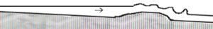
Base levels made a deep impression on me back in my college geology classes because of their important role in the dynamic equilibrium of stream grade. If a section of stream is too steep, the water accelerates, increasing in erosive power and wearing that section down more quickly. If a section of the stream is too gentle, the water slows down, loses its kinetic energy and drops some of its suspended. That section builds up. The steep sections wear down; the gentle sections build up. Given enough time, they will eventually form a smooth curve (when seen from the side).
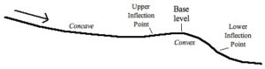
 The lower end of this lovely curve is determined by the local base level. Because erosion can wear this base level down only slowly, the stream equilibrium is more gentle here. The top end of this curve occurs as the stream drops over the edge of the next local base level upstream. Therefore, when we look at a stream’s grade (from the side), we see that it is a series of long concave stretches alternating with short convex stretches over the lip of the local base level.
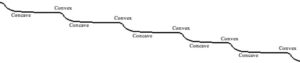 Mathematically, the place where concave turns into convex (and convex turns back into concave) is called an inflection point. Inflection points have major metaphysical significance for me because of the dynamics of shifting balances that underlie them. But this article is hard enough for me to organize without going into that also. Suffice it to say that the base level is flanked by an inflection point on either side. {For river runners, the upper inflection point is marked by the tongue accelerating into a rapid. The lower inflection point is often marked by a hydraulic.}
 As a college student, I conceived of these base levels as major features with miles of stream between them. But as I kayak and go out on my rain walks, I observe that a consistent visual pattern of flowing water is it’s always oscillating in width. Wider then narrower, then wider again. This oscillation in width forces an oscillation in speed. The water speeds up coming into the narrower section and slows down as it passes into the wider section. But if I change how I see cause and effect, then the water is speeding up (and therefore narrowing) as it accelerates over a base level and then slows down as it glides into the next concave (therefore gentling) stretch. The narrow stretches in the water flow are the small-scale base levels. Just as ripples guide my trowel to the high points within my divergences, so stream dynamics focus the stream’s power to erode on the high points, all the tiny base levels.
Every narrowing place now has me examining the upstream shorelines to see if there is a low pass in the divide between the small drainage of this baseline and its adjoining, possibly more absorbent, drainage. Even during heavy rain, much of the surface of the land is not underwater. It can slow and absorb more water if the water is led to the right places.) If I do see a low point along the shoreline, is it lower than the height of a stone dam built on the base level?
Or, conversely, if I see a promising low spot along the side of the runoff, I look for the first set of ripples downstream of it. If I start a porous stone dam at that point, would some of the runoff then diverge onto that now-available path? This new perspective is opening up a whole new terrain of possibilities.
Because of the rocky terrain I am working in, I have the opportunity to respond to many of these possibilities. Most of them are small but here is a third example that exceeded my expectations in a visually amazing way. To show this, I will use two pictures to show how the water flowed before and after I made the dam. I’m using the same post-dam picture so focus on the arrows, not the appearance.
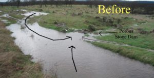 Water Flow before Third Dam
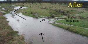 Water Flow after Third Dam
The small flow reversal to the right was predictable but the massive reversal in the road leading beyond the dam extended more than one hundred feet and now leads much of this runoff onto the slopes in the background rather than heading down the steep, narrow channel that my dam is on. As the dam took shape, water always kept flowing through it. But I could see the water flowing from different directions starting to slow down as they encountered the pool forming behind the dam. And then there came this moment when the water within sight of the dam started flowing away from it. It felt like water flowing uphill because the water had been flowing downhill towards the dam and now it was flowing in exactly the opposite direction. It felt like all of natural law was reversed, however, it was a delight to observe closely how natural law still held when a base level was raised.
Back to the inflection points. As I said earlier, the upper inflection point lies where the water starts to accelerate into what river runners call the tongue, the narrowing smooth acceleration of the water arcing towards the heart of the rapid. The lower inflection point is often marked by something called a hydraulic jump. This is where the water has to slow down (because the slope is gentling) but if it slows down, it will get rear-ended by the flow behind it. But it does slow down because it, itself, is rear-ending into the water ahead of it. The jump is a major slowdown of velocity and a conversion of kinetic energy into turbulence. It’s called a jump because in order to keep the same amount of water moving downstream through this sudden slowdown, the depth of the water has to suddenly increase. So the surface of the water suddenly jumps upwards. Dam spillways are engineered to create hydraulic jumps near their base in order to dissipate the energy of the plunge before it’s erosive power reaches the base of the dam. The point of these structures is to convert strong kinetic energy into (from a thermodynamic point of view) heat, a turbulence of dissipating random motion. (Wikipedia has several images in their article on “hydraulic jump”.)
But from the point of view of Gaia, every spinning of potential energy into turbulence is a loss of possibilities for creating yet more possibilities. The last thing Gaia wants (I’m anthropomorphizing) is for potential energy to get turned into kinetic energy that is then “deliberately” wasted in turbulence. This turbulence happens at the lower inflection point downstream of the base level. I’m experimenting with two responses to turbulence there. If there is hydraulic action at the lower inflection point, I start the porous stone dam growth process by laying a large, flattish stone at the heart of the turbulence where it prevents the swirling turbulence from touching and deepening a plunge pool. Then each time I come back, I bring some stones and extend it further.
The second response is where the inflection point has already drilled what I call a gully head down through the sod, forming a narrow, steep-walled, foot-deep gully for a stretch of what would otherwise be a grassy swale where the runoff would flow broadly and smoothly through all the grass stems. Here I am into my second year experimenting with what I am calling stone wedges. Instead of a porous rock dam atop base level, this is a porous rock “dam” that is wedged into the abrupt face of the gully head and then extending downstream to stretch the drop over the gully head into a several foot long cascade. Here is a picture of a two-year old stone wedge. Grass is growing up through the rocks which I take as a good sign.
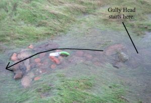 Stone Wedge
Notice how smoothly the water flows without a hydraulic jump at the end.
Rock by rock, a wedge of stones rises against the steep descent just below base level. Their porous length smooths the lower inflection point into a laminar flow so that base level is not eroded down as quickly and grass can fill in some of the gully’s volume. Less of the potential energy within the rain is dissipated as erosive turbulence. More of its potential energy soaks into the land, some of which will be photosynthesized into (a) atmospheric oxygen which fuels so many organic processes and (b) leaf surface that will absorb yet more of the solar radiation that is streaming onto our world and transpire more of the ground moisture back up to fall as rain again.
So a three-part strategy seems to be emerging for possible intervention around each base level.
- The upper inflection point, if it is not entrenched, often offers the best place to create a divergence to split a flow. “Offer a new path before opposing the old.”
- Base level itself offers the best place to use a porous rock dam to raise the base level (but only if it allows the runoff to back up and into a higher, gentler outflow route.)
- The lower inflection point, if it is turbulent, can be a place for stone wedges to split and slow the stream current multiple times so there is no hydraulic jump generating turbulence.
I’m starting to metaphorically see my work as similar to an enzyme. Wikipedia says that “Like all catalysts, enzymes increase the rate of a reaction by lowering its activation energy.” By raising the base levels, my stone dams allow runoff to flow along higher, slower paths than they would otherwise be able to access. These higher paths allow more of the rain’s potential energy to be held upon the land. Similarly, I start to think of the base levels as membranes containing gentle stretches of runoff. As the runoff passes through membranes, potential energy is lost. As the lower base levels rise, more of the runoff can be spread out and contained so that more potential energy can be held on the land within the membranes. (Hillside rice terraces are an extreme form of this.)
Just learning how to play with all of this.
Thank you for the including all the photos….I appreciated the visual while reading your description!
Lovely. Porous stone dams remind me of the usefully porous stick and mud dams beaver use.